Your search for images, within 10km of grid reference J 3138 2427, returns
15,052 images:
( Page 1 2 3 4 5 6 7 8 ... next >> ) [refine search]
[quick refine]

|
Silent Valley Reservoir
by GARRY HARPER geograph for square J3124 Category: Viewpoint On top of Slieve Binnian looking at Silent Valley Reservoir
|

|
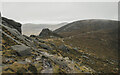
Cloud shrouded North Tor
by Eric Jones geograph for square J3124 Dist:0.3km Category: Tors The North Tor appearing eerie in the mist which quickly rolled in from the Irish Sea
|

|
Granite boulders on North Tor
by Colin Park geograph for square J3124 Dist:0.3km Category: Tors North Tor forms the northern spur to Slieve Binnian and has several granite tors
|

|
On North Tor, the view south towards Slieve Binnian
by Colin Park geograph for square J3124 Dist:0.3km Category: Mountains A good path runs along the ridge from Slieve Binnian passing several fine granite tors. This view is taken looking south from North Tor.
|
|
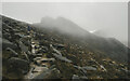
Path on Slieve Binnian
by Rossographer geograph for square J3124 Dist:0.5km Tags: [top:Rocks, Scree, Cliffs] [top:Uplands] [binnian] [type:Geograph] [kingdom of mourne] [weather:mist] [mist] [weather:misty] [misty day] [misty morning] [mountain mist] [Mountains of Mourne] [Mourne] [place:Mourne Mountains] [mournes] [subject:summit] Heading north and descending from the summit of Slieve Binnian. There is a clear path here which heads towards the Buzzard's Roost and drops down above the Ben Crom reservoir.
|
|
Summit, Slieve Binnian
by Rossographer geograph for square J3123 Dist:0.6km Tags: [top:Rocks, Scree, Cliffs] [top:Uplands] [binnian] [type:Geograph] [kingdom of mourne] [Mountains of Mourne] [Mourne] [place:Mourne Mountains] [mournes] [subject:summit] Heading north and descending from the summit of Slieve Binnian. There is a clear path here which heads towards the Buzzard's Roost and drops down above the Ben Crom reservoir.
|

|
Mist shrouded North Tor of Slieve Binnian
by Eric Jones for square J3124 Dist:0.6km Tags: [top:Air, Sky, Weather] [top:Geological interest] [top:Rocks, Scree, Cliffs] [top:Uplands] [type:Close Look] |
|
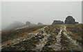
Summit, Slieve Binnian
by Rossographer geograph for square J3123 Dist:0.7km Tags: [top:Rocks, Scree, Cliffs] [top:Uplands] [type:Geograph] [kingdom of mourne] [weather:mist] [mist] [weather:misty] [misty day] [misty morning] [mountain mist] [Mountains of Mourne] [Mourne] [place:Mourne Mountains] [mournes] [subject:summit] The Back Castles, strange rocky outcrops on the north summit of Slieve Binnian.
|

|
Slieve Binnian's Back Castles and North Tor from the Annalong Valley
by Eric Jones for square J3224 Dist:0.7km Tags: [top:Moorland] [top:Rocks, Scree, Cliffs] [top:Uplands] The low rock outcrop on the left is the Percy Bysshe roche moutonnee.
|

|
Binnian's North Top viewed from the Long Seefin ridge
by Eric Jones for square J3224 Dist:0.7km Tags: [top:Rocks, Scree, Cliffs] [top:Uplands] [top:Woodland, Forest] The view across the wooded Annalong valley encompasses, on the left, Douglas Crag and, on the right, the Blue Lough Buttress.
|

|
Glacially transported and deposited boulders above the Silent Valley reservoir
by Eric Jones geograph for square J3024 Dist:0.7km Tags: [top:Rocks, Scree, Cliffs] [top:Uplands] [top:Water resources] [type:Geograph] Ben Crom mountain forms the background.
|

|
The Silent Valley
by Rossographer geograph for square J3024 Dist:0.8km Category: Valley Path and reservoir in the Silent Valley. Doan mountain looms above to the left with a snow capped Slieve Bearnagh beyond.
|

|
The lower reaches of the path ascending towards the col between Binnian North Top and Slievelamagan
by Eric Jones geograph for square J3024 Dist:0.8km Tags: [top:Paths] [top:Roads, Road transport] [top:Uplands] [type:Geograph] Ben Crom forms the background.
|

|
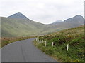
Bend in the Ben Crom Reservoir access road
by Eric Jones geograph for square J3024 Dist:0.8km Tags: [top:Roads, Road transport] [top:Uplands] [type:Geograph] |
|
Bend in the Ben Crom Reservoir Service Road
by Eric Jones geograph for square J3024 Dist:0.8km Tags: [top:Roads, Road transport] [top:Uplands] |
Search took 0.01 secs, ( Page 1 2 3 4 5 6 7 8 ... next >> ) [refine search]
· Login to view KML, GPX, or RSS versions of these results.Expand Word Statistics
Found these results useful? Please Donate
|