Grid reference NS8838
near to Douglas Water, South Lanarkshire, Scotland
Coverage
We have
30 images
in grid square NS8838
Contribute
Explore gridsquare NS8838
Surrounding area
Maps
Loading map... (JavaScript required)
Tip: Click the map to open the coverage map
Sample images
Breakdown list
images taken from NS8838 [1]
A sample of 12 photos from 30
for NS8838
- View this square in the Browser >>>

|
Douglas Water from the air
Looking downstream, the confluence with the River Clyde can be seen. Lanark can be seen in the left distance. he line of the Caledonian Railway's Douglas Branch Link
|

|
Flood Plain of Douglas Water |
|
Wet tracks near Sandilands
by A-M-Jervis
The drainage of the former Muirkirk to Lanark railway line has collapsed in the cutting north of Bridge 15, resulting in a permanent bog. Sandilands station was amongst the trees in the distance, beyond which the old railway line can be... (more)
|

|
Woodland near Harperfield Lodge
by Richard Webb
Steep slopes above the Douglas Water.
|
|
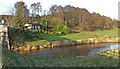
Douglas Water
by wfmillar
Douglasmouth Bridge far left, cottage at Harperfield Lodge.
|

|
Kame and kettle terrain, Sandilands
by Richard Webb
A wet hollow amongst glacial deposits.
|
|
Bridge over the Douglas Water
by G Laird
This bridge is about 1 mile from the point where the Douglas Water flows into the River Clyde.
|

|
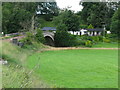
View From The Douglasmouth Bridge
by Rude Health
A view from the Douglasmouth Bridge which carries the minor road over the river Douglas Water, so water, water every where by the look of the flooded field.
|

|
Bridge Over Disused Railway Cutting |
|
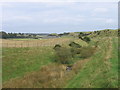
Douglas Water
View downstream about 1Km before emptying into the Clyde.
|

|
Railway over bridge, Sandilands
by Richard Webb
The railway linked Douglas and Lanark, it closed to passengers in 1964.
|

|
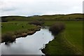
Douglas Water
by wfmillar
Looking down stream from Douglasmouth Bridge.
|
Explore more images in this square: | View Filtering options | View all 30 images page by page >>> |
|