Your search for images, within 10km of grid reference O 227 345, by Eric Jones, returns
1,306 images:
( Page 1 2 3 4 5 6 7 8 ... next >> ) [refine search]
[quick refine]
[2 squares within 4km have no or only one photo - can you add more?]

|
The Dublin Pilot Boat "Camac" returning to port
by Eric Jones for square O2234 Category: Pilot boat This high speed vessel was built in Cork by Safehaven Marine.
Link
|

|
The partly exposed North Bull breakwater
by Eric Jones for square O2234 Dist:0.2km Category: Moles (breakwaters) The seaward end of the Bull Wall is in the form of a breakwater, submerged at high tide.
|

|
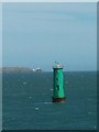
A marker buoy and the North Bull lighthouse at the entrance to the Port of Dublin
by Eric Jones geograph for square O2334 Dist:0.5km Category: Navigational aid |
|
The exposed section of the Bull Wall
by Eric Jones geograph for square O2234 Dist:0.5km Category: Breakwater The end of the exposed section of the wall is marked by a statue of Our Lady Star of the Sea paid for by the contributions of the port workers of Dublin during the Marian... (more)
|
|
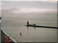
The North Bull Lighthouse
by Eric Jones geograph for square O2334 Dist:0.5km Category: Lighthouse This light is situated at the end of the Bull Wall (a considerable portion of which is submerged at high water). The lighthouse, completed in 1880, flashes green every 10... (more)
|

|
The Star of the Sea statue at the end of the above water section of the Bull Wall
by Eric Jones geograph for square O2234 Dist:0.5km Category: Statues The Star of the Sea (Realt na Mara) statue was erected in 1972. Funded by Dublin Port workers and sailors it was dedicated by Archbishop John Charles McQuaid.... (more)
|
|
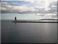
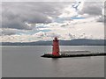
Poolbeg Light
by Eric Jones for square O2334 Dist:0.6km Category: Lighthouse This marks the entrance into the Port of Dublin.
|

|
Poolbeg Lighthouse to Port
by Eric Jones for square O2334 Dist:0.6km Tags: [top:Docks, Harbours] |

|
The Half Moon Swimming Club on Poolbeg Mole
by Eric Jones for square O2233 Dist:0.7km Category: Sea swimming clubhouse Tags: [type:Cross Grid] It would need a full moon before I would go swimming off the Poolbeg Mole.
|
|
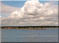
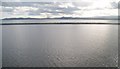
View south across the Poolbeg Mole
by Eric Jones for square O2233 Dist:0.7km Category: Moles (breakwaters) Topped by Poolbeg Road this mole of boulders extends the south bank of the River Liffey two miles or more out into the bay. The coastline of Dublin Bay extending... (more)
|

|
Dublin Port's green North Bull Light to stern
by Eric Jones geograph for square O2334 Dist:0.7km Tags: [top:Docks, Harbours] [top:Estuary, Marine] |
|
|
The Bull Wall
by Eric Jones for square O2235 Dist:0.7km Category: Harbour wall Beyond the Bull Wall is the sandy expanse of North Bull Island with its large golf links. Paragliders can be seen in the distance.
Link
|
|
The red coloured Poolbeg Light
by Eric Jones geograph for square O2334 Dist:0.7km Category: Lighthouse |
|
Poolbeg Lighthouse at the entrance to the port of Dublin
by Eric Jones geograph for square O2334 Dist:0.7km Category: Lighthouse The Poolbeg Lighthouse is at the far end of the South Bull Wall a two kilometre long breakwater built in 1767. This view was taken from the Holyhead-bound Irish Ferries... (more)
|

|
Approaching Poolbeg Lighthouse at the entrance to Dublin Port
by Eric Jones geograph for square O2334 Dist:0.7km Category: Lighthouse |
Search took 0.01 secs, ( Page 1 2 3 4 5 6 7 8 ... next >> ) [refine search]
· Login to view KML, GPX, or RSS versions of these results.Expand Word Statistics
Found these results useful? Please Donate
|