Your search for images, within 10km of grid reference J 362 735, returns
34,721 images:
( Page 1 2 3 4 5 6 7 8 ... next >> ) [refine search]
[quick refine]
|
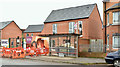
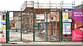
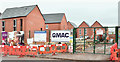
Nos 263-287 Beersbridge Road, Belfast - October 2017(1)
by Albert Bridge geograph for square J3673 Tags: [top:Construction, Development] [top:Housing, Dwellings] [apartments under construction] [Beersbridge Road (Belfast)] [place:Belfast] [subject:construction] [type:Geograph] [Houses under construction] [social housing] Work continuing on the new social housing beside the Beersbridge Road.
|
|
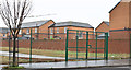
Nos 263-287 Beersbridge Road, Belfast (September 2016)
by Albert Bridge geograph for square J3673 Tags: [top:Construction, Development] [top:Housing, Dwellings] [Beersbridge Road (Belfast)] [place:Belfast] [subject:construction] [development site] [type:Geograph] [Vacant site] Documents, available on the NI Planning Portal, show that the application for planning permission is still under consideration. Elmgrove Primary School is on the left.
|
|
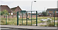
Connswater path works, Belfast - April 2016(4)
by Albert Bridge geograph for square J3673 Tags: [top:Construction, Development] [top:Paths] [place:Belfast] [Connswater] [subject:construction] [path under construction] Construction continuing on the new path between Flora Street (left) and the Connswater. This view is from the Beersbridge Road.
|
|
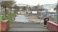
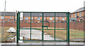
Site, 263 - 287 Beersbridge Road, Belfast - December 2015(1)
by Albert Bridge geograph for square J3673 Tags: [top:Construction, Development] [top:Derelict, Disused] [top:Housing, Dwellings] [place:Belfast] [development site] [housing association] [Vacant site] The cleared site between Elmgrove Primary School and Woodlee Street (right).
|
|
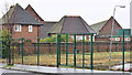
Nos 263-287 Beersbridge Road, Belfast (July 2017)
by Albert Bridge for square J3673 Tags: [top:Construction, Development] [top:Housing, Dwellings] [Beersbridge Road (Belfast)] [place:Belfast] [type:Close Look] [subject:construction] [Houses under construction] [housing association] [social housing] New social housing under construction on what had been a long-term vacant site.
|
|
Site, 263 - 287 Beersbridge Road, Belfast - December 2015(2)
by Albert Bridge geograph for square J3673 Tags: [top:Construction, Development] [top:Derelict, Disused] [top:Housing, Dwellings] [place:Belfast] [development site] [housing association] [Vacant site] The cleared site between Woodlee Street and Grove Street East/Woodlee Court.
|
|
Woodlee Street, Belfast (December 2015)
by Albert Bridge geograph for square J3673 Tags: [top:Construction, Development] [top:Derelict, Disused] [top:Housing, Dwellings] [place:Belfast] [development site] [housing association] [Planning permission application] [Then and now] [Vacant site] The line of the long-since demolished and cleared Woodlee Street. J3673 : Nos 263 - 287 Beersbridge Road, Belfast (April 2018) shows the site after completion of the work.
|
|
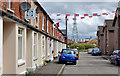
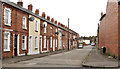
Foxglove Street, Belfast
by Albert Bridge geograph for square J3673 Tags: [top:Housing, Dwellings] [top:Suburb, Urban fringe] [Beersbridge Road (Belfast)] [Belfast] [street] [Terrace houses] A late 19th century street off the Beersbridge Road. One side retains the original terrace houses. The other has been redeveloped. Several streets, on this side of the... (more)
|

|
Bonfire, Belfast
by Rossographer geograph for square J3673 Tags: [top:People, Events] [top:Suburb, Urban fringe] [11th july bonfire] [place:Belfast] [Belfast] [bonfire] [bonfire material] [bonfire site] [subject:event] [type:Geograph] [loyalism] [Loyalist] [pallets] [pile of pallets] [Stack of Pallets] [wooden pallet] [wooden pallets] An 11th night bonfire site Link
|

|
Bonfire, Belfast
by Rossographer for square J3673 Tags: [top:People, Events] [top:Suburb, Urban fringe] [11th july bonfire] [place:Belfast] [Belfast] [bonfire] [bonfire material] [bonfire site] [type:Close Look] [subject:event] [loyalism] [Loyalist] [pallets] [pile of pallets] [Stack of Pallets] [wooden pallet] [wooden pallets] Detail of an 11th night bonfire Link
|
|
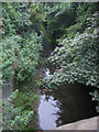
River Connswater, Belfast
by Patrick Brown geograph for square J3673 Category: River The River Connswater seen from the Beersbridge Road, Belfast
|

|
Bonfire, Belfast
by Rossographer geograph for square J3673 Tags: [top:People, Events] [top:Suburb, Urban fringe] [11th july bonfire] [place:Belfast] [Belfast] [bonfire] [bonfire material] [bonfire site] [subject:event] [type:Geograph] [loyalism] [Loyalist] [pallets] [pile of pallets] [Stack of Pallets] [wooden pallet] [wooden pallets] An 11th night bonfire site Link
|
|
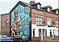
Polish servicemen mural, Foxglove Street, Belfast (February 2017)
by Albert Bridge geograph for square J3673 Tags: [top:Defence, Military] [top:People, Events] [place:Belfast] [type:Geograph] [mural] [street art] [WWII] See J3272 : Polish Air Forces (Polskie Siły Powietrzne) mural, Benburb Street, Belfast August 2016(1). A recently-painted mural at the Beersbridge Road end of Foxglove Street J3673 : Foxglove Street, Belfast. It commemorates the Poles who have served in HM forces.
|
|
Nos 263-287 Beersbridge Road, Belfast - October 2017(2)
by Albert Bridge geograph for square J3673 Tags: [top:Construction, Development] [top:Housing, Dwellings] [apartments under construction] [Beersbridge Road (Belfast)] [place:Belfast] [subject:construction] [type:Geograph] [Houses under construction] [social housing] Work continuing on the new social housing beside the Beersbridge Road. The site extends along the length of the old Woodlee Street.
|
|
Flora Street, Belfast
by Albert Bridge geograph for square J3673 Tags: [top:Suburb, Urban fringe] [Beersbridge Road (Belfast)] [Belfast] [street] A late 19th century street running from Mayflower Street J3673 : Mayflower Street, Belfast to the Beersbridge Road (background).
|
Search took 0.03 secs, ( Page 1 2 3 4 5 6 7 8 ... next >> ) [refine search]
· Login to view KML, GPX, or RSS versions of these results.Expand Word Statistics
Found these results useful? Please Donate
|