Grid reference SU4828
near to Winchester, Hampshire, England
Coverage
We have
410 images
in grid square SU4828
Contribute
Explore gridsquare SU4828
Surrounding area
Maps
Loading map... (JavaScript required)
Tip: Click the map to open the coverage map
A sample of 12 photos from 410
for SU4828
- View this square in the Browser >>>

|
Winchester, former railway bridge
by Mike Faherty
Crossing Garnier Road; once on the Didcot to Southampton line, now part of Sustrans cycle route NCN23.
|

|
Fallodon Nature Reserve (set of 5 images)
by Mr Ignavy
|
|
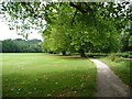
Tree-lined path, Palmer Field, Winchester
On the east bank of the Itchen Navigation. Part of the Itchen Way.
|
|
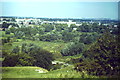
Itchen Valley
by Colin Smith
View from St Catherine's Hill, over Tun Bridge, towards the city of Winchester. The cathedral is the large building visible.
|

|
Winchester College playing fields 'Meads'
Winchester College playing fields (known as 'Meads') with Hunter Tent (the cricket pavilion) on the left and the cathedral in the background
|

|
Sluice from the Itchen Navigation
by Shazz
This is in the water meadows. Another sluice is pictured at SU4828 : The Itchen Navigation looking towards Winchester.
|
|
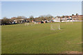
Sports Ground, Bar End
by Peter Facey
|
|
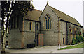
All Saints, Chilcomb, Winchester
by Michael FORD
Victorian Church
|
|
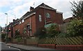
Houses on Bar End Road, Winchester
by David Howard
|

|
Swans on the Itchen
Near Winchester College
|
|
|
Winchester College playing field
by Elaine Hamby
Very old enclosed green where the boys play sports, looking east from the back of the old College buildings. In-camera panorama.
|
|
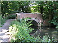
Wharf Bridge, Winchester
Officially the head of navigation, (although a few boats worked a short distance further upstream to serve Wharf Mill), this bridge, built in the 1760s, is the oldest surviving bridge over the River Itchen. The public right of navigation... (more)
|
Explore more images in this square: | View Filtering options | View all 410 images page by page >>> |
|