Grid reference NG5160
near to Lower Tote, Isle of Skye, Scotland
Coverage
We have
54 images
in grid square NG5160
Contribute
Explore gridsquare NG5160
Surrounding area
Maps
Loading map... (JavaScript required)
Tip: Click the map to open the coverage map
A sample of 12 photos from 54
for NG5160
- View this square in the Browser >>>

|
Looking down to Inver Tote
by Gordon Brown
Diatomite was extracted at Loch Cuithir and brought here by narrow gauge railway. Diatomite, also called kieselguhr, is a fine powdered earth used in industry amongst other things as a filler, and also added to nitro-glycerine to make... (more)
|

|
Lealt waterfall |

|
Observation Point
by Russel Wills
To observe the waterfalls on the Lealt River.
|

|
Lealt: waterfall detail
by Chris Downer
Detail of NG5160 : Lealt: waterfall.
|
|
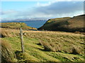
Grazing land at Lealt
With a view towards the island of Rona and in the far distance, the Scottish mainland.
|

|
Lealt lower waterfall, Skye, 1989 |

|
The former Lealt salmon netting station
The salmon fishers' bothy is in the foreground and the store behind.
|

|
Skye Waterfall
by Pam Brophy
|

|
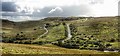
Disused Quarry
by don cload
The old quarry seen from the pathway that leads to the viewpoint of Inver Tote
|

|
The lower falls of Lealt
by N Chadwick
|
|
View south from the Lealt River - Trotternish, Skye
by Ian Hawfinch
|

|
View over the Steep Banks of the Lealt River
by James Emmans
|
Explore more images in this square: | View Filtering options | View all 54 images page by page >>> |
|