Grid reference SP5712
near to Beckley, Oxfordshire, England
Coverage
We have
15 images
in grid square SP5712
Contribute
Explore gridsquare SP5712
Surrounding area
Maps
Loading map... (JavaScript required)
Tip: Click the map to open the coverage map
We have
15 images
for SP5712

|
Roman road near Beckley
The roman road across Otmoor is a bridleway. This section is between the RSPB reserve and the military firing range.
|

|
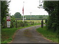
Ot Moor military range
Ot Moor military range. No red flag today, read the signs before using the Roman Road bridleway across Ot Moor
|
|
Entrance to the MOD firing range near Beckley |
|
Track to the MOD rifle range |
|
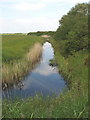
Drainage ditch on Otmoor
View from the roman road across Otmoor. Here it is just between the RSPB area which is being converted back to wetland, and the Ministry of Defence firing range.
|

|
Field by the rifle range
The footpath to Horton-Cum-Studley follows the hedgerow on the right of the picture.
|

|
Entrance to the MoD gunnery range, Otmoor
At present there is no public access beyond this point at any time. My friend ceridwen Link
|

|
Blackthorn blossom along the Roman Road, Otmoor
The date at which blackthorn blossom comes out varies considerably from year to year. Photo posted retrospectively in April 2015 - a year in which blackthorn blossom was later.
|

|
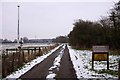
Public bridleway, RSPB Otmoor
Along the northern boundary of Moorleys. Ot Moor was first drained in 1816 and had been divided up into fields by 1830. Since 1997 the RSPB have been recreating wetlands here.
|
|
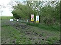
Warning signs at a bridleway gate, Ot Moor
If the cows don't get you the military might! But not every day or every season.
|

|
Bridleway bridge over a silted up drain, Ot Moor
On the route of a Roman road. The little bridge probably dates from 1830 or earlier. Ot Moor was first drained in 1816 and had been divided up into fields by 1830. Since 1997 the RSPB have been recreating wetlands here.
|

|
Silted up drain, from the bridleway bridge, Ot Moor
Ot Moor was first drained in 1816 and had been divided up into fields by 1830. Since 1997 the RSPB have been recreating wetlands here.
|

|
Bridleway on the route of a Roman road, near RSPB Otmoor
Looking north.
|

|
Fields behind Beckley Park
by Dani
|

|
Public footpath protected by wall
by Dani
I believe this wall is part of the security system for the firing range located north of here.
|
|