Grid reference SS5125
near to Alverdiscott, Devon, England
Coverage
We have
31 images
in grid square SS5125
Contribute
Explore gridsquare SS5125
Surrounding area
Maps
Loading map... (JavaScript required)
Tip: Click the map to open the coverage map
Sample images
Breakdown list
taken pre 2000 [1]
A sample of 12 photos from 31
for SS5125
- View this square in the Browser >>>
|
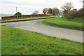
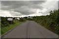
Road junction at Alverdiscott
by Derek Harper
The lane to Haddacott meets the B3232 as it sweeps around a bend; see also SS5125 : B3232 at Alverdiscott.
|
|
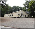
Alverdiscott Community Hall |

|
Alverdiscott : All Saints Church
by Lewis Clarke
Looking towards the church, which isn't lit at night.
|
|
B3232 at Alverdiscott
View north from the parish churchyard; showing the Methodist church on the left.
|

|
Alverdiscott Methodist Church (set of 3 images) |

|
Ordnance Survey Cut Mark
by Adrian Dust
This OS cut mark can be found on the north face of All Saints Church. It marks a point 137.818m above mean sea level.
|
|
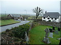
Stony Cross
A hamlet in the parish of Alverdiscott.
|
|
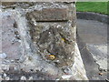
Ordnance Survey Cut Mark
by Peter Wood
This mark can be found on the wall of All Saints Church.
For more detail see : Link
|
|
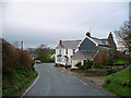
Approaching Stoney Cross from the west |

|
An incident on the B3232 at Alverdiscott |

|
Alverdiscott : B3232
by Lewis Clarke
Looking along the road.
|
|
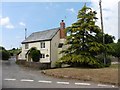
Cottage at Stony Cross |
Explore more images in this square: | View Filtering options | View all 31 images page by page >>> |
|