Grid reference TQ1507
3 km from Sompting, West Sussex, England
Coverage
We have
41 images
in grid square TQ1507
Contribute
Explore gridsquare TQ1507
Surrounding area
Maps
Loading map... (JavaScript required)
Tip: Click the map to open the coverage map
Sample images
Breakdown list
A sample of 12 photos from 41
for TQ1507
- View this square in the Browser >>>

|
Lychpole Hill
by Simon Carey
A view of the brow of the hill. Rampion Offshore Wind Farm can be seen in the distance to the right.
|

|
Farm buildings, Lychpole Farm
by Peter Holmes
Tractor on Public bridleway 2078.
|

|
Lychpole Farm
by Chris Shaw
Farm building on the E side of the grid square.
|

|
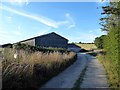
Barns by bridleway at Lychpole Farm
by Shazz
|

|
Lychpole Farm from Lychpole Hill
The hill beyond is Steep Down.
|

|
Towards Beggars Bush
by Graham Horn
The hamlet lies in TQ1607. Closer to hand is grazing land belonging to Lychpole Farm.
|

|
Lychpole Farm
by Dave Spicer
Looking east from the Access land near Cissbury Ring
|

|
House Field (1)
by Simon Carey
The name of the field according to Sompting's 1840 tithe map that has now been split into two fields. This section is located to the immediate east of public bridleway 2076 and north of Lychpole Farm house. See also TQ1507 : House Field (2).
|

|
Approaching Lychpole Farm
by Graham Horn
This field seems to be lying fallow, having only a grass crop and not being grazed.
|

|
Track at Lychpole farm
by Peter Holmes
Public bridleway 2078.
|
|
Beggars Bush Barn
by Simon Carey
Modern barns built after the Second World War.
|

|
Towards Lychpole Hill
by Graham Horn
Various layers of land use. A flinty chalk field close at hand followed by a productive arable crop, then pasture for cattle and sheep and finally woodland on the north-eastern slopes of Lychpole Hill. Somehow it reminded me of tiramisu.
|
Explore more images in this square: | View Filtering options | View all 41 images page by page >>> |
|