Grid reference TQ9765
near to Conyer, Kent, England
Coverage
We have
42 images
in grid square TQ9765
Contribute
Explore gridsquare TQ9765
Surrounding area
Maps
Loading map... (JavaScript required)
Tip: Click the map to open the coverage map
Sample images
Breakdown list
images taken from TQ9765 [1]
A sample of 12 photos from 42
for TQ9765
- View this square in the Browser >>>

|
The Swale (set of 2 images)
by N Chadwick
|

|
South Deep, Conyer (set of 6 images) |

|
Drainage ditches, Teynham Level |

|
Saxon Shore Way at Conyer
This is the footpath of the Saxon Shore Way that leads from Conyer to Oare, near Faversham. These coasts have been used to farm oysters, since the roman times.
|

|
Trailer with portable tanks
There is plenty of natural water about for livestock, so what this is here for is a bit of a mystery.
|

|
Boats moored in South Deep near Fowley Island |

|
Sheep and lambs by the Swale
by Peter S
|

|
South Deep, The Swale (set of 2 images)
by N Chadwick
|

|
Rifle Range, Teynham Level |

|
Remains of rifle range |

|
Small beach, The Swale
by N Chadwick
|
|
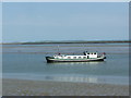
Boat on the Swale |
Explore more images in this square: | View Filtering options | View all 42 images page by page >>> |
|