Grid reference SK5807
near to Birstall, Leicestershire, England
Coverage
We have
56 images
in grid square SK5807
Contribute
Explore gridsquare SK5807
Surrounding area
Maps
Loading map... (JavaScript required)
Tip: Click the map to open the coverage map
Sample images
Breakdown list
images taken from SK5807 [2]
A sample of 12 photos from 56
for SK5807
- View this square in the Browser >>>
|
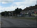
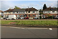
Local shops on Red Hill Way (A563) |
|
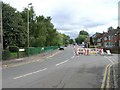
Roadworks on Thurcaston Road, Leicester
Just off to the left of the picture is Belgrave St. Peter's C of E Primary School, evidenced by the yellow zig-zag road markings. It must be chaos at picking up time with these roadworks in place.
|
|
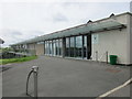
Greenacres near Birstall
A former community centre now being developed as a skills training centre by the Great Central Railway.
|

|
Louise Kelham Photography on New Year's Day 2026
Well and truly closed on New Year's Day 2026! Abbey Lane was very quiet with little traffic or people about.
|
|
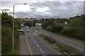
A563 looking west from the footbridge near Leicester North
by Robert Eva
|

|
Marwood Road in Stocking Farm, Leicester
by Mat Fascione
|
|
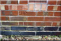
Benchmark on #81 Woodstock Road
Ordnance Survey cut mark benchmark described on the Bench Mark Database at Link
|
|
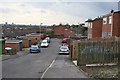
Chilcombe Close, Stocking Farm, Leicester
by Kate Jewell
The centre of Stocking Farm is approximately 90 metres above sea level and there are fantastic views east, across the city centre.
|

|
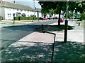
Pedestrian cut-through
Linking Beaumanor Road to Abbey Lane
|
|
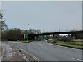
Redhill Circle, Belgrave, Leicester
by Tim Heaton
Leicester's Inner Ring Road crossing the A6
|
|
Marwood Road, Leicester |
|
Red Hill Way, Mowmacre Hill
by David Howard
|
Explore more images in this square: | View Filtering options | View all 56 images page by page >>> |
|