Grid reference SD3608
near to Haskayne, Lancashire, England
Coverage
We have
59 images
in grid square SD3608
Contribute
Explore gridsquare SD3608
Surrounding area
Maps
Loading map... (JavaScript required)
Tip: Click the map to open the coverage map
Sample images
Breakdown list
A sample of 12 photos from 59
for SD3608
- View this square in the Browser >>>

|
Old milemarker by the Leeds & Liverpool Canal, Halshall
Milemarker by the Leeds & Liverpool Canal, in parish of Halshall (West Lancashire District), North of Harker's Bridge (No 23).
Inscription reads:-
: L'POOL / 18 / MILES : : LEEDS / 109¼ / MILES :
Grade II listed.
List... (more)
|

|
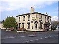
The Ship Inn, near Haskayne
by John Slater
|
|
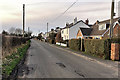
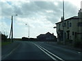
Station Road
by David Dixon
|
|
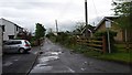
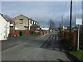
Smithy Lane
A view of Smithy Lane, Barton.
|
|
The closed Blue Bell pub on Mill Brow at Barton |
|
Looking towards Haskayne
by David Long
From Harkers Bridge on Plex Lane
|

|
The course of Wanishar Brook
Mapped by the OS as 'Warnshaw Brook' in 1845.
|
|
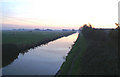
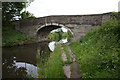
Leeds & Liverpool Canal (set of 2 images)
by Ian S
At bridge 23, Harkers Bridge.
|

|
Where work on the Leeds - Liverpool Canal started on 5th November 1770
by Gary Rogers
|
|
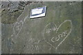
The start of the Leeds-Liverpool Canal, Halsall
The plaque reads:
Leeds & Liverpool Canal
Canal cutting began here
The building of the Leeds & Liverpool Canal formally began here.
The Honourable Charles Mordaunt of Halsall, accompanied by surveyor Samuel Holmes, ceremoniously... (more)
|
|
Southport Road, Barton
by Colin Pyle
|
|
Smithy Lane, Barton
by JThomas
Looking east from Southport Road.
|
Explore more images in this square: | View Filtering options | View all 59 images page by page >>> |
|