Grid reference SD6495
near to Firbank, Cumbria, England
Coverage
We have
11 images
in grid square SD6495
Contribute
Explore gridsquare SD6495
Surrounding area
Maps
Loading map... (JavaScript required)
Tip: Click the map to open the coverage map
We have
11 images
for SD6495

|
Chapel Beck Stream Junction, Howgills
by Chris Upson
|

|
Summit of Seat Knott 344 metres
by David Brown
|

|
Bridleway below Seat Knott
by Ian Taylor
Looking northwards up the valley of Long Rigg Beck, to Fell Head on the left, and White Fell Head on the right. The bracken covered ridge in the right mid-distance is Bram Rigg.
|
|
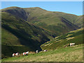
Sheep and Fell Head
by Karl and Ali
Sheep grazing on the flanks of Seat Knott. The valley of Long Rigg Beck leads to the foot of Long Rigg which ends on the summit of Fell Head (640m), the most westerly two thousand foot summit in the Howgills.
|

|
Long Rigg Beck from Seat Knott
by David Brown
|

|
Castley from below Seat Knott
by Ian Taylor
Looking NW across the valley of Chapel Beck, to the slopes below Castley Knotts.
The wall running up the hillside on the right shows the boundary of the open fells.
|

|
Bench mark on the bridleway
by Karl and Ali
A cut mark on a stone embedded in the bridleway which runs from Four Lane Ends and up onto White Fell. I could not see it listed for the square on the OS bench mark locator. Looking over to Seat Knott and Arant Haw.
|

|
Knolls of Seat Knott
Seat Knott is a feature of the declining west ridge of Arant Haw once it has gone through a few changes of direction.
Fell Head is the distant hill.
|

|
Rushes at Swang Head
Swang Head is a col between the minor feature of Seat Knott and the continuing ridge to Arant Haw.
The highest distant hill is Fell Head.
|

|
Chapel Beck
The head of Chapel Beck at the confluence of Bram Rigg Beck with Long Rigg Beck.
|

|
OS Bench Mark
Ordnance Survey pivot bench mark from the first, 19th century, levelling directly under the gate at the end of the track from Castley to White Fell. 804.5 feet above old datum.
|
|