Grid reference SD6596
3 km from Lowgill, Cumbria, England
Coverage
We have
12 images
in grid square SD6596
Contribute
Explore gridsquare SD6596
Surrounding area
Maps
Loading map... (JavaScript required)
Tip: Click the map to open the coverage map
We have
12 images
for SD6596

|
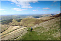
The Flank of Bram Rigg
Taken below the path, looking towards Seat Knott
|

|
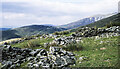
Sheepfold on Bram Rigg
by David Brown
The descent of Bram Rigg is possibly the best in the Howgills. The path runs along the steep slope of Bram Rigg Top before going relatively gently down Bram Rigg. The fine view to the west can be appreciated without always looking at your feet!
|

|
Descending White Fell, Howgills
by Karl and Ali
The bridleway down the west ridge.
|

|
View SE from Bram Rigg
by Ian Taylor
Looking across the upper valley of Bram Rigg Beck. The spur on the right is named as Bland on the 1:50000 map. The 1:25000 map shows Bland further west.
|

|
Sheepfold on Bram Rigg
by Ian Taylor
Rowantree Grains forms the skyline.
|
|
Descending White Fell towards Long Rigg Beck
From the summit plateau of the Howgill Fells, which we'd traversed from Linghaw to the Calf, this bridleway provides an easy descent to the west, eventually emerging at Four Lane Ends on the minor road from Sedbergh to Low... (more)
|
|
Ruined sheepfold on Bram Rigg
The ruin is on the 400 m. contour at Bram Rigg which is the west ridge of the 2000 foot summit, Bram Rigg Top. Ian Taylor has another image of the ruin - Link .
Beyond the collapsed stonework is the... (more)
|

|
White Fell
Nearing the top of White Fell.
|

|
Bram Rigg
Bram Rigg with Brant Fell in the background.
|

|
White Fell
Steep path leading up White Fell.
|

|
View from White Fell
Looking across the Lune Valley towards Killington Lake and Morecambe Bay.
|

|
OS Bench Mark
Ordnance Survey pivot bench mark from the first, 19th century, levelling, on south side of track up White Fell. One of the three arrows has split off the rock. 1452.3 feet above old datum.
|
|