Grid reference SO0433
near to Garthbrengy, Powys, Wales
Coverage
We have
11 images
in grid square SO0433
Contribute
Explore gridsquare SO0433
Surrounding area
Maps
Loading map... (JavaScript required)
Tip: Click the map to open the coverage map
We have
11 images
for SO0433
|
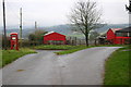
The Village of Garthbrengy
Outbuildings of Danreglwys colour match the telephone box at Garthbrengy
|
|
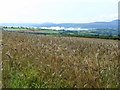
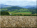
Barley land at Garthbrengy 1
Looking south-east towards some mist hanging in the Usk valley.
|
|
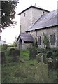
St David's Church, Garthbrengy |
|
St David's Church, Garthbrengy
I believe the graveyard is still in use, however, this isolated rural church is now closed.
|
|
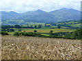
Barley land at Garthbrengy 2
View south over farmland north of Brecon towards the familiar outline of the Beacons in the blue distance.
|
|
Barley land at Garthbrengy 3
Looking south-west towards the Pen-y-crug hillfort north-west of Brecon.
|
|
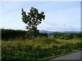
Young oak tree
By the road between Garthbrengy and Llandefaelog.
|
|
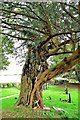
A Wonderful Yew
by paul wood
St David's Church Garthbrengy has in recent time ceased its service as a place of Worship but is well worth a visit for its excellent collection of Common Yews.
|
|
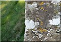
Ordnance Survey Cut Mark
by Adrian Dust
This OS cut mark can be found on the south face of St David's Church. It marks a point 291.698m above mean sea level.
|

|
Ordnance Survey Rivet
by Adrian Dust
This OS rivet can be found on the rock SE side of the road. It marks a point 261.817m above mean sea level.
|

|
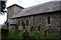
Parish Church of St David at Garthbrengy north of Brecon
A Grade II* listed building originally dating from the medieval period but with both 17th and 19th century additions and alterations.
The prominent tower is said to be from the 17th century.
The windows in the picture on the north side of... (more)
|
|