Grid reference SY8491
near to Lane End, Dorset, England
Coverage
We have
13 images
in grid square SY8491
Contribute
Explore gridsquare SY8491
Surrounding area
Maps
Loading map... (JavaScript required)
Tip: Click the map to open the coverage map
We have
13 images
for SY8491

|
MOD footpath, Chamberlaynes Heath
by John Lamper
This is a permissive footpath which crosses MOD land and which leads to a public footpath. The yellow markers on such paths are an indication that the area between them must be followed and this will have been checked for any unexploded... (more)
|

|
Stile onto Chamberlayne's Heath
This stile gives access to two footpaths across the Bovington tank training grounds.
|

|
Bend in the Road |

|
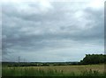
Chamberlaynes Heath
by Nigel Mykura
View across the heath from the permissable footpath alongside the minor road from
Wool to Bere Regis. Most of this is military training areas.
|
|
Line of pylons |

|
Permissible Footpath
by Nigel Mykura
This path marked by yellow topped poles allows the public to access a path on the Military Training Area that would otherwise be difficult to reach.
|
|
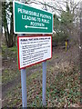
Permissive footpath sign Chamberlaynes Heath
by Nigel Mykura
This sign shows the instructions for walkers using the public paths across the tank training area. One of the yellow posts marking the path can be seen behind the sign. See SY8491 : Permissible Footpath
|

|
Bovington Camp - Training Area
by Peter Elsdon
'Beware Military Vehicles' - Looking west across the North Training Area at Chamberlaynes Heath.
|

|
Chamberlayne's Heath
by Mike Faherty
Dry or moist heathland, most of it on the Bovington Training Area North.
|

|
Chamberlayne's Heath, stile
by Mike Faherty
At the eastern entrance to the path across the military training area.
|

|
Chamberlayne's Heath, military road
by Mike Faherty
Used for vehicle training on Bovington Training Area North.
|

|
Chamberlayne's Heath, footpath
by Mike Faherty
Across the heath, on Bovington Training Area North. The path is regularly marked with yellow-tipped posts.
|

|
Minor road towards Bere Regis
by JThomas
|
|