Grid reference TL1331
near to Pirton, Hertfordshire, England
Coverage
We have
12 images
in grid square TL1331
Contribute
Explore gridsquare TL1331
Surrounding area
Maps
Loading map... (JavaScript required)
Tip: Click the map to open the coverage map
We have
12 images
for TL1331
|
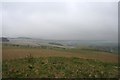
Knocking Knoll
A short deviation from the Icknield Way to the top of Knocking Knoll. From this high point, the Long Barrow below, you can see Shillington (on a clear day).
The Straw Plaiters walk which begins at The Motte & Bailey Pub in Pirton is... (more)
|
|
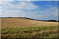
Rolling Farmland and County Boundary Near Pirton
I believe the hedgeline visible on the horizon is the county boundary between Herts and Beds.
|

|
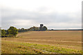
Farmland, Pirton
by Andrew Smith
A footpath to the west of the village follows the edge of a large field with a cereal crop growing in it.
|

|
Farmland west of Pirton
by JThomas
|
|
Farmland leading to Water Tower on the horizon |
|
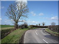
Sharp bend in Shillington Road
by JThomas
Heading west from Pirton.
|
|
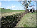
Drainage ditch beside Shillington Road
by JThomas
|

|
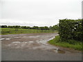
Farm track off Shillington Road
by JThomas
|
|
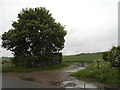
Track to Rectory Farm, Pirton
by David Howard
|
|
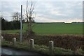
Field by Shillington Road, Pirton
by David Howard
|
|
Field by Shillington Road, Pirton
by David Howard
|

|
Wood Lane on its way to Pirton |
|